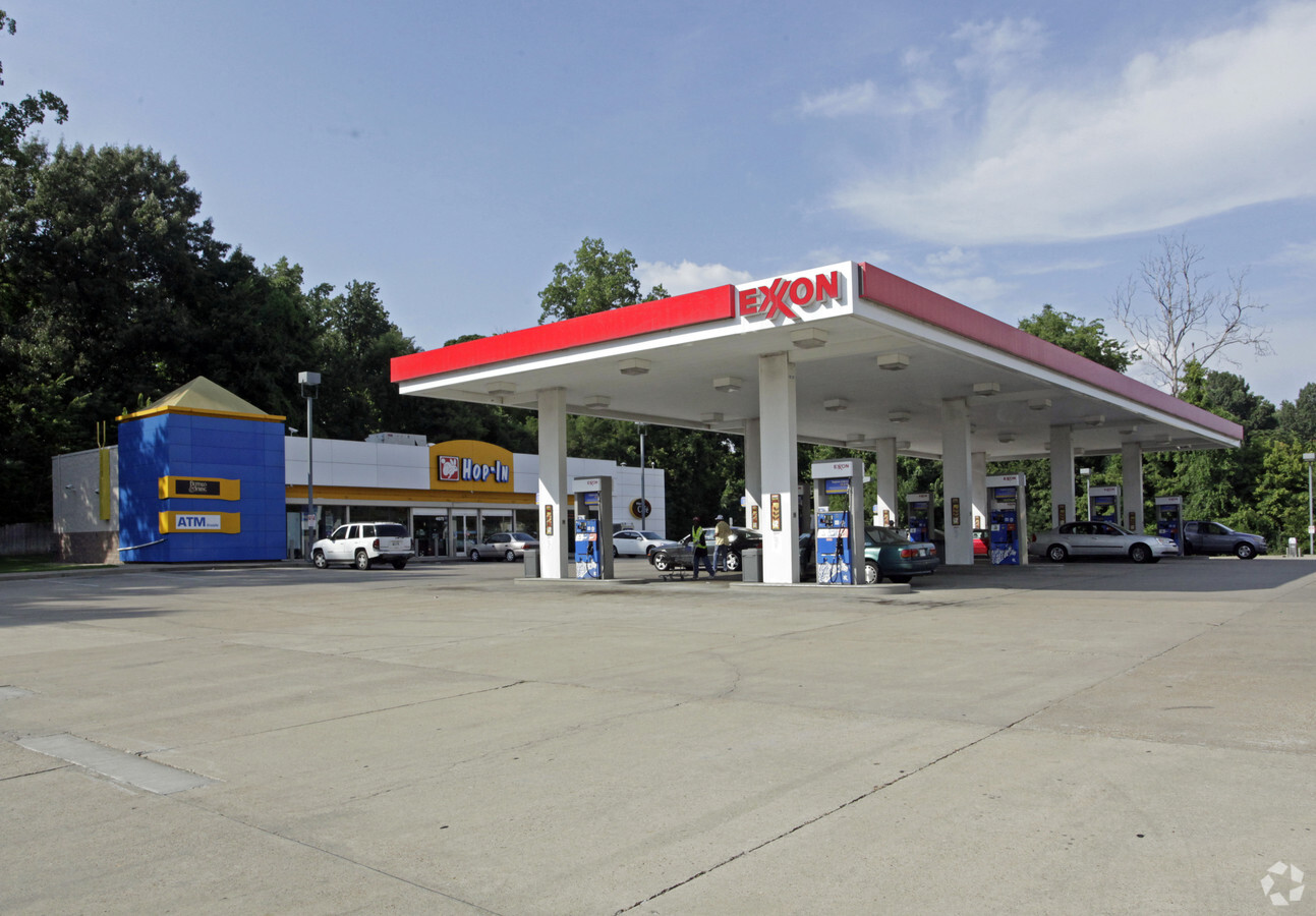
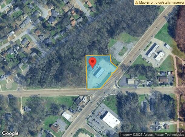
Property Record
4675 S Highway 61 St, Memphis, TN 38109

NEARBY LISTINGS FOR SALE OR LEASE
Property Detail
4675 S Highway 61 St
07-5155-0-0009C
Acklena Land Company Subdivision
Storebuilding
SEE MAP GRID NS SHELBY DR COR HWY 61 (NW)
X
Shelby
05035C0475E
Tennessee
2023
1.89 AC
2024
South
022310
Memphis
4,237 SF
Memphis, TN-MS-AR
DEMOGRAPHICS near 4675 S Highway 61 St
1 Mile
3 Mile
5 Mile
2024 Total Population
6,534
39,391
91,531
2029 Population
6,433
39,078
93,145
Pop Growth 2024-2029
(1.55%)
(0.79%)
+ 1.76%
Average Age
40
40
39
2024 Total Households
2,426
14,952
34,774
HH Growth 2024-2029
(1.69%)
(0.88%)
+ 1.68%
Median Household Inc
$40,833
$41,766
$43,232
Avg Household Size
2.60
2.60
2.60
2024 Avg HH Vehicles
2.00
2.00
2.00
Median Home Value
$65,008
$73,715
$98,286
Median Year Built
1961
1964
1968
Nearby Places
- Restaurants
- Banks
- Shops
- Fitness
- Groceries
PUBLIC TRANSPORTATION
COMMUTER RAIL
Central Station (Riverfront Loop - Memphis Area Transit Authority Trolley (MataTrolley))
DRIVE
WALK
Distance
Central Station (Riverfront Loop - Memphis Area Transit Authority Trolley (MataTrolley))
14 min
8.6 mi
AIRPORT
Memphis International
DRIVE
WALK
Distance
Memphis International
13 min
8.0 mi
Freight Ports
Port of Shreveport
DRIVE
WALK
Distance
Port of Shreveport
409 min
375.7 mi
Nearby Properties
Address
Land Use
TOTAL SIZE
Lot Size
Zoning
Address
Land Use
TOTAL SIZE
Lot Size
Zoning
1,009,363 SF
78.56 AC
EMP
Address
Land Use
TOTAL SIZE
Lot Size
Zoning
2,569.30 AC
IH
Address
Land Use
TOTAL SIZE
Lot Size
Zoning
95,307 SF
25.91 AC
RU-3
Address
Land Use
TOTAL SIZE
Lot Size
Zoning
79,658 SF
7 AC
RU-3
Address
Land Use
TOTAL SIZE
Lot Size
Zoning
79,340 SF
7 AC
RU-3
Address
Land Use
TOTAL SIZE
Lot Size
Zoning
37,631 SF
3.38 AC
CMU-2
Address
Land Use
TOTAL SIZE
Lot Size
Zoning
13,978 SF
7 AC
RU-3
Address
Land Use
TOTAL SIZE
Lot Size
Zoning
12,789 SF
19.12 AC
RU-1
Address
Land Use
TOTAL SIZE
Lot Size
Zoning
35,280 SF
5.80 AC
CMU-3
Address
Land Use
TOTAL SIZE
Lot Size
Zoning
91,965 SF
14.64 AC
RU-3
Address
Land Use
TOTAL SIZE
Lot Size
Zoning
27,084 SF
3.26 AC
CMU-1
Address
Land Use
TOTAL SIZE
Lot Size
Zoning
104,069 SF
12.50 AC
RU-3
Address
Land Use
TOTAL SIZE
Lot Size
Zoning
8,568 SF
102.43 AC
R-6
Address
Land Use
TOTAL SIZE
Lot Size
Zoning
23,860 SF
11.54 AC
R-6
Address
Land Use
TOTAL SIZE
Lot Size
Zoning
21,140 SF
7.53 AC
CMU-3
Address
Land Use
TOTAL SIZE
Lot Size
Zoning
79.90 AC
EMP
Address
Land Use
TOTAL SIZE
Lot Size
Zoning
55,234 SF
4.99 AC
EMP
Address
Land Use
TOTAL SIZE
Lot Size
Zoning
9.10 AC
R-6
Address
Land Use
TOTAL SIZE
Lot Size
Zoning
98,588 SF
12.44 AC
CMU-3
Address
Land Use
TOTAL SIZE
Lot Size
Zoning
135.33 AC
R-10
Address
Land Use
TOTAL SIZE
Lot Size
Zoning
140.72 AC
R-6
Address
Land Use
TOTAL SIZE
Lot Size
Zoning
16,456 SF
3.22 AC
CMU-3
Address
Land Use
TOTAL SIZE
Lot Size
Zoning
7,116 SF
6.43 AC
EMP
Address
Land Use
TOTAL SIZE
Lot Size
Zoning
9,970 SF
4.58 AC
RU-3
Address
Land Use
TOTAL SIZE
Lot Size
Zoning
2,268 SF
1.82 AC
R-6
Address
Land Use
TOTAL SIZE
Lot Size
Zoning
10.43 AC
RU-3
Address
Land Use
TOTAL SIZE
Lot Size
Zoning
33.86 AC
R-8
Address
Land Use
TOTAL SIZE
Lot Size
Zoning
11,232 SF
3.73 AC
CMU-3
Address
Land Use
TOTAL SIZE
Lot Size
Zoning
6,480 SF
1.75 AC
R-10
Address
Land Use
TOTAL SIZE
Lot Size
Zoning
8,786 SF
1.60 AC
R-8
The World's #1 Commercial Real Estate Marketplace
Connect with us
© 2025 CoStar Group
The information above has been obtained from sources believed reliable. While we do not doubt its accuracy we have not verified it and make no guarantee, warranty or representation about it. It is your responsibility to independently confirm its accuracy and completeness. Any projections, opinions, assumptions, or estimates used are for example only and do not represent the current or future performance of the property. The value of this transaction to you depends on tax and other factors which should be evaluated by your tax, financial, and legal advisors. You and your advisors should conduct a careful, independent investigation of the property to determine to your satisfaction the suitability of the property for your needs.